
Topographic survey is a crucial foundation for infrastructure and construction projects, requiring the processing of large amounts of data with high accuracy. However, when this task is not a core competency, implementing it with internal resources often puts companies under significant pressure. Faced with this reality, many companies have chosen to outsource this task to Topographic Survey outsourcing service to optimize their processes while still ensuring project efficiency.
What are topographic survey outsourcing service?
Topographic survey outsourcing service is the service that converts field survey data (elevation, coordinates, and survey points) into a detailed digital topographic map. This map fully represents natural and man-made features on the land, such as contour lines, spot elevations, existing structures, trees, and technical infrastructure systems.
Clients use this service as a basis for design, planning, obtaining building permits, and project construction. It helps land surveying companies, civil engineers, architects, and project developers obtain accurate and visual data to execute their projects effectively.

Depending on the project’s goals, different client groups can apply topographic survey maps to their projects:
- Land Surveying Firms: Convert field survey data into topographic maps for clients or regulatory authorities, and use outsourcing to manage large workloads.
- Civil Engineering Firms: Use accurate topographic maps as the basis for designing grading, drainage, site plans and subdivisions.
- Architectural & Land Development Firms: Use topographic maps to plan site layouts, arrange structures, and apply for building permits.
- Construction Contractors & Engineering Consultants: Create more accurate construction plans, calculate earthwork volumes, and verify as-built conditions with the support of outsourcing topographic survey service.
- Government Agencies / Councils: Use topographic maps to review project documents and manage urban planning and infrastructure.
Therefore, Topographic Surveying outsourcing not only serves surveying companies but also effectively supports the entire value chain from design to construction and project management.

Standards and regulations that Topographic Survey outsourcing service must comply with
To ensure the accuracy and consistency of drawings, outsourcing providers like Aidedo always comply with international, national and regional standards, specifically:
International & Software Standards:
- AutoCAD Civil 3D, Carlson: Adherence to DWG drawing export standards.
- ISO 128 (International Standard for Technical Drawings)
United States (US) Standards:
- ALTA/NSPS Land Title Survey Standards: National standards for surveys, applied when conducting ALTA/Topo surveys.
- ASCE (American Society of Civil Engineers) Guidelines
- State Plane Coordinate System (SPCS) for each specific state.
Australia Standards:
- AHD (Australian Height Datum) for elevation.
- AS/NZS 5488 – Classification of Subsurface Utility Information
- Compliance with local council requirements.
- UK/Europe (EU) Standards:
- RICS (Royal Institution of Chartered Surveyors) guidelines
- BS 1192 / PAS 1192 for digital data and BIM.
- Ordinance Survey Grid & Datum
Canada Standards:
- CLS (Canada Lands Survey Standards)
- NAD83 (CSRS) – North American Datum for coordinates.
- General Standards (if not specifically designated by the client):
- ANSI/ASME Y14 (Drafting standards – US)
- ISO 9001 Quality Management System (to ensure quality processes).
- Local City/Council submission standards.
In addition to the standards mentioned above, the drawings must also adhere to the specific format, styles, and CAD Template of each client company. This is the most critical factor to ensure that the final product, whether executed by an outsourcing provider or an in-house team, maintains consistency, uniformity, and is easy to manage thereafter.
Simultaneously,, the drafting process is carried out using specialized software such as AutoCAD, Autodesk Civil 3D, Carlson Civil Suite and ArcGIS Pro. Applying these tools along with the technical standards mentioned above helps Topographic Survey outsourcing service ensure that the provided drawings are accurate, in either DWG or DGN format, and fully meet client requirements.

Input data required for Topographic Survey outsourcing service to implement the project
A high-quality topographic map not only depends on adherence to technical standards but also on complete and accurate input data. This is the “raw material” that the team of engineers and specialists processes into the final product that meets the client’s requirements.
The important input data and documents typically required in Topographic Surveying outsourcing are:
Survey Data Files
- CSV / TXT / XYZ: These files contain coordinates (X, Y, Z), point numbers, and point descriptions.
- Field Book (FBK) / RAW: This is data directly from a total station.
- Preliminary DXF / DWG: This is a draft drawing from the survey equipment.
Point Cloud / Scan Data (if available)
- LAS / LAZ / E57 / RCP: These files contain 3D laser scan data from LiDAR, drones, or scanners.
- They are used to create detailed surfaces or 3D topographic models.
Field Notes & Supporting Documents
- Field notes from the site survey.
- Coordinate systems & datums used (e.g., NAD83, WGS84, AHD).
- Benchmark information (standard elevation markers).
- Client’s technical requirements (contour interval, drawing scale, presentation standards).
Reference Documents (if available)
- Planning maps, boundary plans, subdivision plans.
- Site photos or drone imagery.
- Related design documents (if integration is needed).
The quality of the drawing is always directly proportional to the reliability of the source data. The more complete and standardized the data is with clear coordinates, datum and benchmarks the more accurate the processing results will be, minimizing errors and shortening the correction time.
Therefore, providers of Topographic Survey outsourcing service often require clients to hand over complete data files, including point data, point clouds, field notes, and reference documents, to ensure the final product meets the highest technical standards.
In cases where the handed-over data package is incomplete, we will rely on a detailed inspection checklist to promptly remind or request supplementation, helping to ensure the deployment process remains smooth and the final product maintains optimal quality.

Standard workflow for outsourcing Topographic Survey service
When all technical standards are followed and the input data is fully prepared, these factors all serve one crucial goal: to ensure the topographic survey drafting process is smooth, accurate, and efficient.
A typical topographic survey project goes through the following basic steps:
- Preparation & Survey Planning
- Field Survey
- Raw Data Processing
- Topographic Survey Drafting
- Review, Delivery & Application
Of these, the topographic map drafting stage is the key step, and it is also the point where many clients choose to outsource to professional companies like Aidedo. With an experienced team and an optimized process, Aidedo executes projects in three clear steps to ensure the final product is both technically precise and meets all client requirements:
Step 1: Field Data Collection
- Pre-survey preparation: Before going to the site, the field crew reviews available documents such as Plat, Deed, FEMA flood maps, and Parcel ID (PID). The property boundary, easements, and setbacks may be pre-drawn in Autodesk Civil 3D or Carlson Survey software and positioned correctly on a geolocation map to support field data collection.
- On-site survey: Establishing a control network – The first task on site is to use GPS/RTK equipment to tie the survey into the national grid or State Plane Coordinate System.
- Conducting the topographic survey – The crew measures both coordinates and elevations for all natural and man-made features within the project area, typically using Total Station and GPS. Each survey point is coded with standard abbreviations (e.g., CL = Centerline, EP = Edge of Pavement, WM = Water Meter) to streamline the drafting process.
Step 2: Data Processing and Drafting
- After the fieldwork, the collected survey data is processed in the office.
- Survey points are imported into Autodesk Civil 3D, Carlson then aligned with the property boundary prepared during Step 1.
- Using field notes and site photos, the drafting team completes the linework, applies survey blocks for features such as utilities and trees, and generates surface contours to represent the terrain.
Step 3: Deliverables
- The final deliverables are provided in both DWG/DGN and PDF formats.
- The drawing includes property boundaries, spot elevations, contour lines, existing improvements, visible utilities, benchmarks, and a vicinity map, giving clients a clear and accurate representation of current site conditions for use in design, permitting, and construction.
- Review, Delivery, & Application
- The provider or client reviews the drawing and requests revisions (if any).
- The final drawing is delivered.
- The drawing is applied for: infrastructure design, planning, building permit applications, grading and drainage, or project construction.

>>> Learn more about how aidedo executed the Topographic Survey drawing project here
Topographic Survey drawing delivery standards
When all input data is complete and the project is executed following Aidedo’s standard workflow, clients will receive the final topographic survey drawing within 24 hours.
This drawing is meticulously prepared, adheres to international technical standards, and includes all necessary components, such as:
- Land address and lot number (section, township, range, city, county, state)
- Benchmark
- Legal description
- Basis of bearing
- Horizontal/Vertical datum
- Survey notes
- Survey’s certificate
- Flood plan
- Utility note
- Contour lines
- Spot elevation
- All existing works
- Survey boundary
- Legend, north arrow, scale, vicinity map, abbreviations
To clearly illustrate the delivery criteria in Topographic Surveying outsourcing, Aidedo provides a sample drawing Sample Project to help clients visually assess the quality and technical compliance.
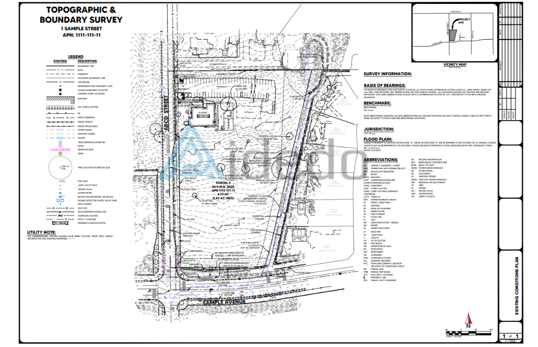


Sample project images confirm Aidedo as a reputable provider in Topographic Survey outsourcing service.
Why choose Aidedo to carry out a topographic Survey project?
With over 10,000 international projects completed and more than 100 loyal clients in the US, Australia, Canada, the UK, and many other developing countries, Aidedo has proven its outstanding capability in the field of Topographic Surveying outsourcing. We have a deep understanding of the detailed requirements in various forms, are familiar with the internal standards of each partner, and always adjust our processes flexibly to fit how clients work.

Beyond our extensive experience, Aidedo offers clear competitive advantages in outsourcing Topographic Survey service:
- We are skilled in and flexibly use various specialized software, such as Civil 3D, AutoCAD, and Carlson (currently less common in Vietnam).
- We communicate quickly, even on weekends and holidays, as soon as the team receives a request.
- Our work process is always clear. For pilot projects, we provide detailed steps to allow clients to easily compare them with their current methods.
- Our schedule is flexible, with a 6-day workweek. We are also ready to work overtime in the evenings, on Sundays, or during holidays (except for the Lunar New Year break) to meet urgent project deadlines.
- During our partnership, we work closely with clients to build a standardized checklist, thereby optimizing the effectiveness of our Topographic Survey outsourcing service.
- We discuss with clients to create a standard checklist and optimize the workflow between both parties.
- We are ready to proactively adapt to any working platform, including communication tools and data storage systems as required.
- Before delivery, our products undergo a multi-tiered quality control process to ensure absolute accuracy and demonstrate the highest level of professionalism.
What clients say about Aidedo?
Along with that direct feedback from clients, Aidedo is also rated by ASCE – The American Society of Civil Engineers as a reliable outsourcing solution.
In addition to the video and image testimonials we’ve shared, if you require further verification, Aidedo is ready to provide a specific contact list. This allows you to proactively call or email clients who have experienced our services directly. You are welcome to discuss and ask questions about any aspect, from service quality and workflows to actual costs. Our goal is to help you gain a complete and clear understanding before making a decision to partner with us.
To better understand how Aidedo operates, please refer to the “How we work” section. For questions related to pricing, policies or project-related issues, please refer to the FAQs section.
FAQs about Topographic Survey outsourcing service
At Aidedo, Topographic Survey projects in particular and Land Surveying service in general are usually completed within 24 hours of receiving a request from the client. For highly complex projects, we conduct an assessment immediately upon receiving the information and provide a detailed plan for the execution time of each item, making it easy for clients to monitor progress and coordinate proactively.
In cases where the deployment time needs to be shortened, Aidedo is ready to arrange staff to work overtime, including on holidays, to ensure the deadline is met as required. Specifically, we commit that if we fail to hand over on time as agreed, the client will receive a 100% refund within 24 hours.
At Aidedo, we use specialized software like Civil 3D and Carlson Software to implement and draft Topographic Survey projects. For point cloud data in common formats (e57, LAS/LAZ), we use Autodesk Recap to read, process, and integrate them into our workflow, ensuring the highest accuracy and efficiency.
Aidedo offers Topographic Survey outsourcing service with the aim of optimizing costs, shortening delivery time and ensuring compatibility with all data standards required by clients. Instead of just receiving a drawing, you will have in hand a complete, reliable set of technical data to implement the project immediately. Please contact us via email contact@aidedo.com or fill in the form below for specific advice.
In addition to topographic service, Aidedo also performs many other specialized items, you can refer to the Land Surveying services section.

GET STARTED WITH A FREE TRIAL
Please fill out the form and we'll be in touch within 12 hours!
Related posts

FINAL SURVEY DRAFTING OUTSOURCING SERVICE
Are you in urgent need of Final Survey Drafting Outsourcing Service for your clients to...

POINT CLOUD TO CAD CONVERSION SERVICES
Are you looking for point cloud to CAD conversion services to quickly process the volume...

CAD Outsourcing Services at Aidedo: Cut Your Costs by 50%
Looking to reduce costs and improve efficiency in your CAD projects? At Aidedo, we offer...

PLOT PLAN SURVEY DRAFTING SERVICE
Have you ever outsourced Plot Plan Survey Drafting Service but ended up spending too much...

Discover Premium CAD Services with Aidedo
Efficiency and accuracy are critical in design and engineering, especially for businesses in construction, civil...

Grading and Drainage Plan Outsourcing Service
If you’ve ever outsourced your work or considered civil engineering outsourcing services, grading and drainage...