
- Are you looking for point cloud to CAD conversion services to quickly process the volume of point cloud data from 3D laser scanning projects but lack in-house personnel and don’t have enough time to deploy on schedule?
- Are you facing difficulties in recruiting or retaining engineers specializing in CAD and BIM, while demands for 3D scan to CAD services suddenly arise, causing projects to be stalled?
- Have you outsourced point cloud to CAD conversion services before but received inaccurate drawings, not aligned with your company’s technical form template, or encountered communication difficulties that made revisions time-consuming and affected the progress?
- Are you concerned that expanding your official workforce to handle internal surveys, point cloud to floor plans, or elevation data from point clouds will lead to a cumbersome system, making it difficult to control the costs of maintaining specialized technical software, office space, and personnel training, and lacking flexibility when project volumes fluctuate unpredictably?
- Do you need a team with sufficient technical capability to immediately receive 3D scan to CAD conversion services data, process it according to your standards, coordinate easily remotely, and be ready to start work as soon as you need them?
- Do you want a point cloud to elevation and point cloud to CAD conversion solution that can scale with your workload, allowing your in-house team to focus on core design tasks instead of spending time on raw data processing?
From the above questions, it can be clearly seen that the demand for converting 3D scan data to technical drawings is not merely a drafting outsourcing job, but an essential part of the operational chain of companies active in the field of land survey. Whether it’s a small company struggling with engineer recruitment, a medium-sized company needing to optimize costs and increase flexibility, or large entities that have previously outsourced but were not truly satisfied with their former partners, point cloud to CAD conversion services still offers a practical and effective solution.
This service not only solves the problems of human resources and costs, but also helps companies control output quality, ensure progress, and easily expand or shrink processing scale according to needs at different times. Therefore, in the next section, we will clearly analyze who point cloud to CAD conversion services are truly for, so you can determine whether this service is suitable for your company’s operating model and operational strategy.

What kinds of issues are point cloud to CAD conversion services suitable for?
Point cloud to CAD conversion services aren’t just a technical option; they’re a practical operational solution for companies in the Land Survey field that frequently work with point cloud field data collected from 3D laser scanning, LIDAR, or drone photogrammetry technologies. While this data offers high accuracy, it creates significant pressure during post-processing as companies must transform millions to billions of data points into detailed, clear technical drawings ready for engineering design.
For small-scale Land Survey companies, where the head often directly manages projects, performs surveying, and simultaneously oversees company operations, the pressure of post-scanning data processing is no simple problem. When the number of projects suddenly increases or clients demand CAD drawings with urgent deadlines, they often lack sufficient personnel, don’t have technicians specialized in creating drawings from point clouds, or simply don’t want to invest in additional software and equipment just to handle a certain volume of temporary work. In such cases, point cloud to CAD conversion services act as a flexible extension, helping small companies quickly obtain high-quality drawings without needing to expand their team or bear the burden of fixed costs. Once the point cloud is complete, drawings like floor plans from point clouds, elevations from point clouds, or extracting elevation data from point clouds are also executed quickly, according to technical standards, and delivered on time as their clients require.
For medium to large-scale Land Survey companies, the challenge isn’t just a lack of personnel, but optimizing resources. They already have a team of highly skilled engineers but still face localized staff shortages at certain times, sudden surges in data volume from large projects, or urgent client demands. In such situations, maintaining productivity without overwhelming the internal team is a top priority. 3D scan to CAD services allow them to outsource point cloud data while retaining control over processes, formats, and technical standards. Deliverables like point cloud to floor plans, point cloud to elevations, or internal survey processing packages are all executed according to specific templates, with quality control and delivery by committed deadlines. This enables their in-house team to focus on specialized tasks, reducing the burden of time-consuming and labor-intensive technical processing steps.

It’s impossible not to mention the group of Land Survey companies that have been or are currently outsourcing but have had negative experiences. Drawing errors like incorrect dimensions, missing annotations, or wrong formats often cause them to lose credibility with clients and waste additional time on corrections. That’s also why they need a provider of point cloud to CAD conversion services with deep technical expertise, a multi-layered quality control process, flexible coordination capabilities, and a fast response time. When the service can deliver accurate drawings right from the first time and work according to each client company’s specific standards, then outsourcing is no longer a risk but becomes part of a long-term development strategy.
Finally, for Land Survey service companies in developed markets like the US, Australia, Scotland, Ireland, Canada, etc., where technical labor costs are high and recruitment is very difficult, Point cloud to CAD services offer a superior advantage in terms of cost and deployment time. With flexible project-based payment mechanisms, no long-term commitments, and rapid scalability, they can easily maintain profit margins in their service packages while still ensuring output quality meets end-client expectations.
Regardless of their scale, from lean small companies to large companies managing hundreds of projects simultaneously, the common need remains to convert point cloud data into technical drawings accurately, quickly, and flexibly. Point cloud to CAD conversion services are precisely the solution that helps Land Survey companies effectively, securely, and reliably solve their technical, operational and cost challenges.
What are the values gained when a company outsources point cloud to CAD conversion services?
Outsourcing point cloud to CAD conversion services isn’t merely handing over drafting work to a third party. It’s a strategic decision that helps companies optimize their operational model, enhance the effective use of 3D scan data, and simultaneously focus resources on higher-value core activities. For companies operating in the Land Survey sector, the benefits derived from outsourcing this service are very clear and provide long-term leverage.
First, companies save a significant amount of time and technical costs. Processing point cloud data requires specialized software infrastructure, from tools for point cloud registration and cleaning to technical modeling software like AutoCAD, Revit, or BIM modules. If a company had to invest in all the software itself and train engineers specializing in creating drawings from 3D scan to CAD services, it would face high fixed costs, uneven workloads, and difficulty in controlling operational efficiency. Outsourcing allows companies to eliminate these initial investment costs while only paying for the exact volume of work incurred during specific periods. This is especially suitable for projects involving internal surveys, creating floor plans from point clouds, or extracting elevation data from point clouds, which typically don’t occur continuously weekly but rather in cycles according to the actual surveying and drafting progress.

Secondly, outsourcing point cloud to CAD services provides the flexibility to scale up and down according to project needs without having to expand your internal staff. In the surveying industry, unstable workloads are common. There are times when a company only has a few small drawings, but there are also periods when hundreds of gigabytes of data from multiple projects need to be processed simultaneously. Outsourcing allows companies to react quickly to these fluctuations without increasing long-term costs or overwhelming the drafting team. Drawings like point cloud to floor plans, point cloud to elevations, or elevations from point clouds can be done in parallel by multiple specialized engineering teams with clear quality control processes, helping to ensure project progress and accuracy.
Third, collaborating with an experienced 3D scan to CAD conversion services provider helps improve the quality of the final drawings. Not all engineers are specifically trained to process field scan data. Modeling from point clouds not only requires software skills but also a deep understanding of the data’s nature, accurate identification of technical surfaces, error control, and correct modeling according to technical conventions. A partner specializing in point cloud to CAD conversion services will have established multi-layered quality assurance processes, a standardized drawing format system, and clear communication capabilities throughout the entire implementation. As a result, companies can be confident that every drawing received meets technical standards, ready for client handover or coordination with other relevant parties.
Another significant value is the ability to shorten project deployment time. With an in-house drafting team, a drawing generated from 3D scan data can sometimes take several days, especially if it includes detailed requirements such as architectural models, floor plans, building elevations, or interior surveys. In contrast, a specialized provider handling point cloud to floor plans or elevation data from point clouds often has the capability to break down workloads, optimize processes, and deliver faster without compromising accuracy. This is particularly meaningful when end-clients require quicker turnaround times or when the drawings are the basis for subsequent approval steps.

Finally, outsourcing helps companies minimize operational risks. Expanding an in-house drafting team comes with personnel risks, training costs, unexpected attrition, and the cost of maintaining staff during periods of low workload. By outsourcing the point cloud processing phase, companies only need to focus on quality control and integrating the drawings into the overall design process. Therefore, point cloud to CAD services not only provides technical support but also helps companies achieve stability, control, and sustainability in their operations.
In summary, outsourcing point cloud to CAD conversion services delivers simultaneous benefits across three aspects: technical, operational, and financial. From the ability to quickly process drawings like 3D scan to CAD services, floor plans from point clouds, elevations from point clouds, to flexible scalability, guaranteed deadlines, and enhanced output quality, this is a comprehensive solution for Land Survey companies seeking efficiency in their methods, expertise in their products, and optimization in their costs.
Aidedo – A trusted provider of point cloud to CAD conversion services you can rely on.
It’s not by chance that hundreds of Land Survey companies in the US, Australia, UK, Canada, Ireland, and other developed countries entrust their Land Survey projects, including point cloud services with their 3D scan data, to Aidedo. From 2019 until now, the team in Ho Chi Minh City has completed over 10,000 large and small projects, including point cloud conversions of hundreds of acres of residential areas, highways, and complex commercial building chains. That body of practical experience, accumulated through many different local standards, ensures that all point cloud to CAD conversion services requirements are processed correctly right from the first time.

Aidedo’s strength lies in its team of over 50 engineers selected from Vietnam’s leading technical universities. We are proficient in AutoCAD, Autodesk Civil 3D, Revit, InfraWorks, Carlson, ArcGIS, along with specialized tools for point cloud processing and hydraulic analysis such as Vehicle Tracking, HydroCAD, and HEC-RAS. Their deep understanding of software helps Aidedo accurately reconstruct all types of data, from 3D scan to CAD conversion services for infrastructure projects to point cloud to CAD services for detailed topographic maps.
Regarding the process, your point cloud data is cleaned, common coordinates registered, and classified using a modular workflow, then recreated into clear products: floor plan from point cloud, point cloud to elevation, elevation data from point cloud, or internal survey reports. Three layers of verification measure every millimeter of error, and a commitment to deliver the first drawing within 24 hours for a project helps you keep submission on schedule, without needing repetitive revisions.

In addition to quality, Aidedo also offers a financial advantage. Operating in Vietnam allows for up to a 50% reduction in labor and infrastructure costs compared to hiring engineers in developed markets. Our flexible payment model hourly, fixed-package, or dedicated team helps you control your budget at each stage. The ability to scale up personnel within forty-eight hours and adherence to international standard NDAs ensure your laser scan data remains secure, freeing your in-house team to focus on core values.
From point cloud to floor plans for new residential areas, 3D scan to CAD services for renovated roadways, to point cloud to CAD services for entire urban-scale projects, Aidedo has proven its capability through tangible results, clear processes, and a commitment to quality. If you are seeking a reliable partner to transform 3D scan data into accurate technical drawings, Aidedo is a trustworthy choice.
Why choose Aidedo over other providers?
Firstly, Aidedo completely eliminates the burden of software licensing. You no longer have to invest in Civil 3D, Carlson, 12D Model, InfraWorks, HydroCAD, or Vehicle Tracking because our entire ecosystem of specialized tools is already equipped and proficiently used daily in our point cloud to CAD services process.

Next is the issue of fixed costs. When partnering with Aidedo, your company doesn’t need to hire more engineers, pay salaries, insurance, or taxes, nor worry about office and equipment costs. You only pay for the exact volume of work incurred, whether it’s a floor plan from point cloud, elevation data from point cloud, or a large-scale internal survey package. Our flexible payment model helps keep your budget under control without long-term commitments.
Time is also a key advantage. Our GMT+7 engineering team starts processing data as soon as clients in the US, Australia, Canada, Ireland, Scotland, and other developed countries finish their workday. Thanks to this continuous workflow, over 90% of 3D scan to CAD conversion services projects are delivered within 24 hours. You wake up to accurate floor plans from point clouds or elevations from point clouds, ready for the next design phase.

Aidedo’s real-world capability has been market-tested. As of early 2025, we’ve completed over 10,000 international projects, serving more than 100 loyal clients in the US, Australia, Canada, Scotland, Ireland, and more. Over fifty full-time engineers are currently working across four offices in Ho Chi Minh City, ready to scale up to meet the growing workload in the near future.
Drawing quality is ensured through a three-stage control process. First is input verification, followed by cross-referencing layers and symbols against the client’s template, and finally, the drafting team leader reviews and approves. As a result, the revision request rate is almost zero, whether it’s a point cloud to floor plan or point cloud to elevation.
Regarding security, all laser scan data is processed on our private cloud infrastructure, with strict access permissions and rigorous adherence to NDA agreements. No files leave our controlled environment, ensuring absolute safety for your intellectual property.

Finally, Aidedo commits to a one hundred percent refund within twenty-four hours if drawings are delivered late or do not meet technical error tolerances. This commitment affirms the responsibility and quality standards we set for all point cloud to CAD services projects.
With extensive experience, precise processes, and superior processing speed, Aidedo provides a reliable point cloud to CAD conversion services solution that helps your company save costs, accelerate timelines, and elevate drawing quality right from the start.
How does Aidedo perform point cloud to CAD conversion services?
1. What is a point cloud?
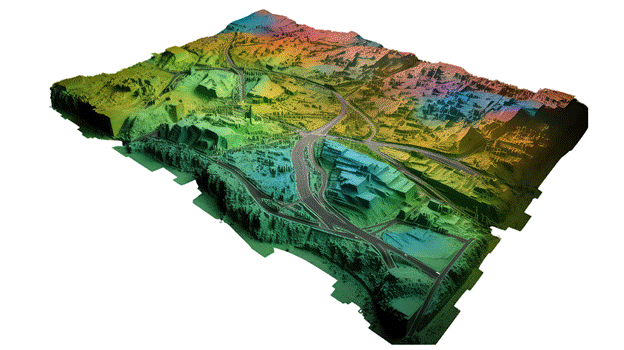
A point cloud is a set of data points in 3D space, captured using tools like laser scanners (LiDAR) or 3D cameras. Each point represents a spot on a surface with coordinates (x, y, z) and may include details like color or brightness. Point clouds are used to create 3D models of real-world objects or spaces, such as buildings or landscapes.
Common point cloud formats:
- LAS (Laser File Format): A widely used binary format developed by the American Society for Photogrammetry and Remote Sensing (ASPRS) for storing 3D point cloud data, especially from LiDAR.
- LAZ (Compressed LAS): A compressed version of the LAS format, using lossless compression.
- RCP (Autodesk Recap Project File): RCP is a proprietary file format developed by Autodesk for use with its Recap software, designed for storing and managing point cloud data. It serves as a project file that references one or more RCS (Recap Scan) files
These formats work well with common software and handle large datasets effectively.
2. Why use point cloud technology for floor plan creation?
- Accuracy: Point clouds are highly precise, reducing errors compared to manual measurements, especially for complex or uneven spaces.
- Speed: Scanning a building with LiDAR or 3D scanners is faster than traditional methods, capturing entire rooms in minutes.
Point clouds are perfect for creating floor plans that show a building’s current state, useful for renovations or property management.
However, point cloud technology requires expensive equipment, software, and skills to process the data.
3. Workflow for creating a floor plan using point cloud data
Step 1: Collecting and Preparing Point Cloud Data
Scanning the Site: The client uses a 3D scanner (e.g., FARO, Leica, or Trimble) to capture the building or space. Multiple scans from different angles ensure full coverage.
Processing Data: Software like Autodesk Recap, FARO Scene, or Leica Cyclone combines the scans into a single 3D model.
Exporting Data: The point cloud is saved as an RCP file, which links to RCS files containing the scan data.
Step 2: Receiving and Checking Point Cloud Data (Aidedo’s role)
Receiving Data: You receive the RCP file and its related RCS files from the client
Checking Data: Ensure all necessary files are included (a complete RCS dataset typically includes):
- RCS: The core point cloud scan file containing 3D data
- DIFF: Differential data used for comparing scans
- LLT: Low-level transformation data used for precise alignment of scans.
- Thumbnail: Preview images of the scan for reference.
- RCC: Metadata or configuration files containing scan settings and parameters
Verification: Use Autodesk Recap to check the point cloud for completeness, proper alignment, and accuracy, ensuring it represents the space correctly
Step 3: Importing the Point Cloud Data into Civil 3D
Setup: Open Autodesk Civil 3D and start a new project
Importing: Load the RCP file using the “Attach Point Cloud” tool on the insert bar, which includes the RCS files
Coordinate System: Set the correct coordinate system to align the point cloud with the project’s location
• Display: Adjust settings (e.g., point density or color) to highlight key features like walls or floors
Step 4: Creating linework from Point Cloud into a Floor Plan
Creating a section: In Civil 3D, cut a horizontal slice through the point cloud at floor level (e.g., 1.5 meters high) to show walls, doors, and windows. Use the “Section Plane” tool
Drawing Lines: Trace the point cloud to create 2D lines for walls, doors, and windows. Use polylines and Civil 3D’s snapping tools to ensure accuracy by aligning with the point cloud
Step 5: Finalizing and Reviewing the Floor Plan
Adding Details: Add labels, measurements, and symbols (e.g., for doors or windows) to complete the floor plan
Checking Accuracy: Compare the floor plan to the point cloud in ReCap to ensure all features are correct and none are missing. Verify measurements and scale
Exporting: Save the floor plan as a DWG, PDF, or other format for the client or project needs
This will be a big trend in surveying in the next few years. We know this from numbers directly from clients who use point cloud technology. The amount of work for projects using this has grown a lot in the last year. This is easy to understand because this technology helps make surveys faster and better.
To keep up with this trend, the Aidedo team always works hard to learn the software skills needed. This helps us use point cloud data well and meet high demands.
Pricing policy applied to point cloud to CAD conversion services at Aidedo
At Aidedo, point cloud to CAD conversion services and other technical solutions are built upon two clear, flexible pricing models, designed to optimally meet the actual needs of each client:
1. Hourly payment
In this model, clients only pay for the exact volume of work performed. Aidedo does not charge any additional fees beyond the actual value. We also provide a dedicated management system for clients, allowing you to track progress, processing time, and all project report content throughout the implementation. This is an ideal option for projects in the expansion phase, with frequently changing scopes, or requiring high flexibility in budget control and work planning.
2. Fixed-Price quotation per work item
For clients who need a specific cost upfront for internal approvals or easy budget control, Aidedo will conduct a detailed analysis of project requirements and provide a clear, fixed-price quotation, accompanied by a specific implementation roadmap. This option helps ensure financial stability and minimizes risks arising during the work process.
Whichever option you choose, Aidedo always commits to only charging if the results meet the agreed-upon schedule and quality from the beginning. Furthermore, we offer the first project completely free of charge, as an invitation for you to experience and evaluate our team’s capabilities before deciding on a long-term partnership.
If you would like to know the estimated cost for your specific project, please send your request to contact@aidedo.com or fill out the contact form below. Our team will respond quickly within one to two company hours, and no later than twelve hours, with a detailed quotation and a commitment of no hidden costs throughout the implementation..
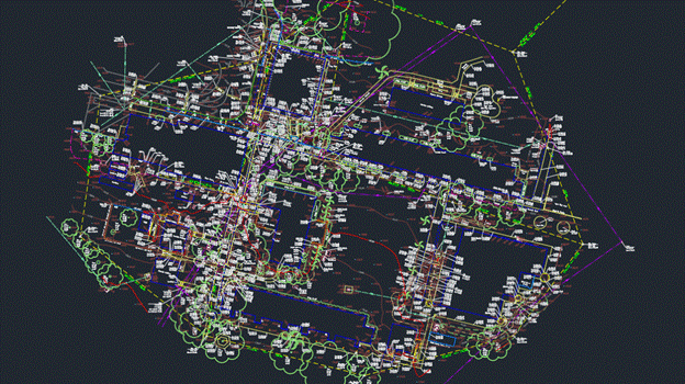
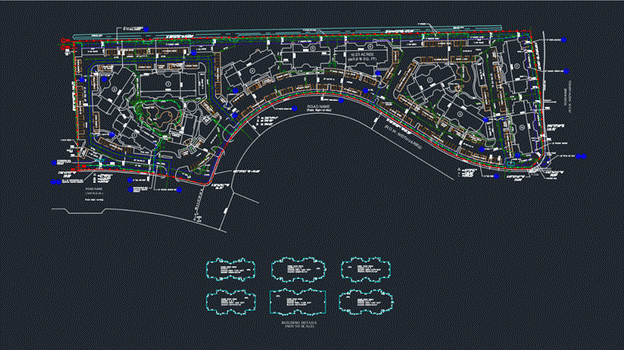
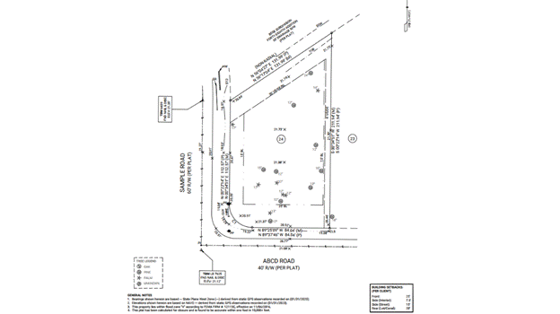
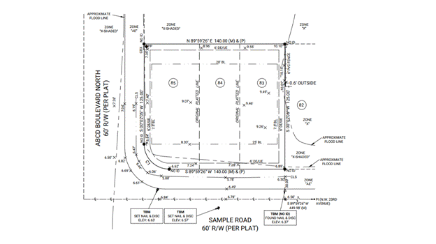
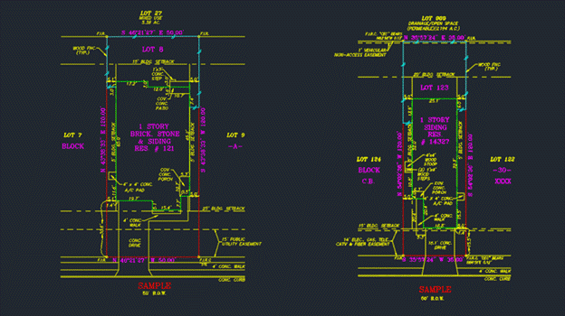
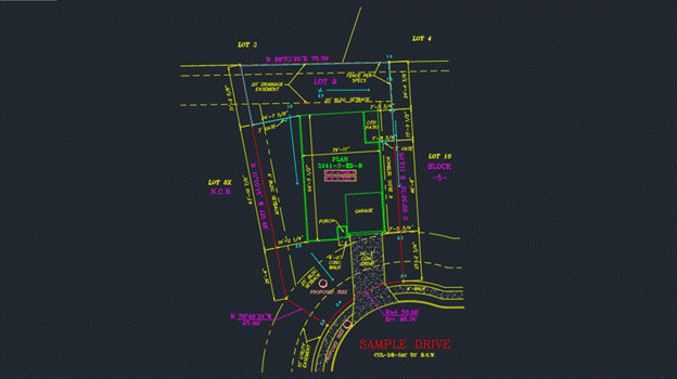
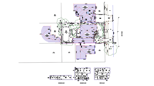
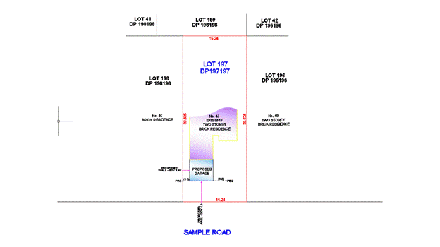
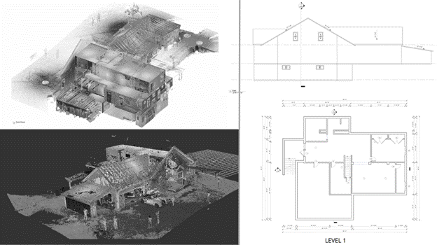
Sample projects Aidedo has done


Client feedback
Other services that Aidedo provides
In addition to drafting topographic survey drawings, Aidedo also provides many other land survey drafting services to meet all of our clients’ surveying needs, such as:
TOPOGRAPHIC SURVEY
ALTA SURVEY
TREE SURVEY
BOUNDARY SURVEY
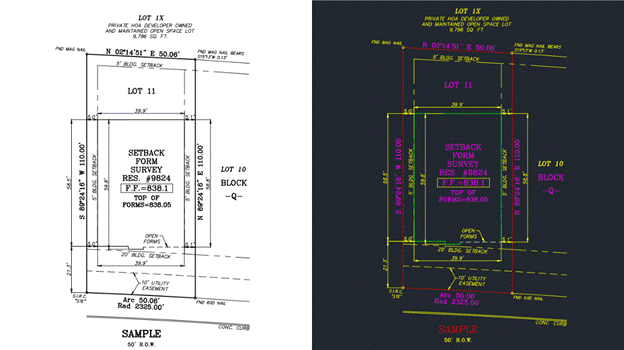
SETBACK SURVEY
FINAL SURVEY
CONTOURS PLAN
PLOT PLAN
DETAIL/INTERNAL SURVEY
SET OUT/PEG OUT SURVEY
3D SURVEY MODELING
POINT CLOUD TO FLOOR PLAN, ELEVATIONS
The process of working with Aidedo
Aidedo understands that the foundation of every long-term partnership lies in a transparent, flexible, and convenient service process. That’s why we’ve streamlined our entire workflow into three core stages, making it easy for clients to track and interact:
Step 1: Submit Project Request
First, you send your project description via email to contact@aidedo.com or fill out the online form at the end of the article. Providing detailed data from the outset allows the Aidedo team to quickly grasp the project’s objectives, scope, and direction, enabling us to propose a suitable solution in the shortest possible time.
Step 2: In-Depth Online Discussion
After receiving your information, we will proactively schedule an online discussion via Google Meet, Zoom, Microsoft Teams, or your preferred platform. This discussion aims to clarify the workload, estimated budget, coordination methods, and implementation roadmap. Aidedo will also present similar completed projects, answer any questions, and help clients better understand our professional capabilities and quality control process.
Step 3: Utilize Free Trial
Once both parties agree on the cooperation terms, Aidedo will immediately deploy a use free trial project. During this phase, we apply the same processes and quality standards as an official project, providing clients with an objective basis for evaluation before signing a long-term contract. If urgent deployment is needed, the actual project can begin immediately after the consultation. Regardless of the format, you always have the right to refuse payment if the final product does not meet expectations for progress or quality.
This three-step process ensures clarity, convenience, and flexibility, while also demonstrating Aidedo’s commitment to prioritizing client benefits and satisfaction.
Overall, for companies seeking to optimize their 3D scan data processing workflow, Point Cloud to CAD Conversion Services offers an efficient, flexible, and cost-effective approach. This service not only helps shorten project deployment time but also increases proactive control over quality and technical resources. Partnering with a highly specialized firm like Aidedo, with clear validation processes and rapid scalability, will help you overcome internal challenges related to personnel, costs, and deadlines while maintaining technical accuracy in every drawing.
Send your request today via email to contact@aidedo.com or fill out the registration form below for direct consultation, a detailed quote, and to experience our Point Cloud to CAD Conversion Services for your first project completely free !

GET STARTED WITH A FREE TRIAL
Please fill out the form and we'll be in touch within 12 hours!
Related posts

FINAL SURVEY DRAFTING OUTSOURCING SERVICE
Are you in urgent need of Final Survey Drafting Outsourcing Service for your clients to...

ALTA SURVEY DRAFTING OUTSOURCING SERVICE
The ALTA survey drafting outsourcing service is precisely the choice many land survey companies in...

CAD Outsourcing Services at Aidedo: Cut Your Costs by 50%
Looking to reduce costs and improve efficiency in your CAD projects? At Aidedo, we offer...

OUTSOURCING SETBACK SURVEY DRAFTING SERVICE
As the number of projects rapidly increases and technical requirements become more stringent, handling all...

AS-BUILT SURFACE 3D MODEL SERVICES
As-Built 3D surface model services have become a practical solution for the land survey industry,...

TOPOGRAPHIC SURVEY OUTSOURCING SERVICE
Topographic survey is a crucial foundation for infrastructure and construction projects, requiring the processing of...