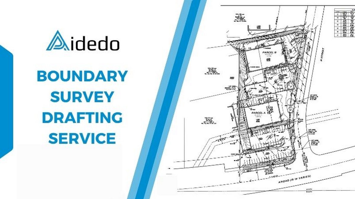
- Are you in need of Boundary Survey Drafting Service to prepare land boundary drawings for land subdivision, construction permits, transfer of ownership or completing legal documents but you don’t want your internal team to be overloaded due to unexpected workload?
- You don’t want to invest more in specialized CAD software, technical management systems or recruit additional personnel just to handle a few incidental boundary drawings each month, when the maintenance costs are too high compared to actual needs?
- Have you ever outsourced Boundary Survey Drafting services but encountered problems because the drawings did not fully show boundary markers, coordinates, side lengths, survey directions, or lacked easements, causing your documents to be returned, requiring multiple revisions and slowing down the entire project?
- Or are you looking for a provider that can thoroughly understand your company’s technical standards, do it right from the beginning, coordinate flexibly, and are ready to support when needed, especially with drawings requiring high legal accuracy such as a boundary survey?
Who is a boundary survey drafting service suitable for?
Boundary Survey Drafting is the type of drawing with the highest legal validity in the system of survey drawings. This is the foundation for determining land ownership, and serves as the basis for land subdivision, buying and selling, applying for construction permits, or submitting documents to authorities. And precisely because of this special nature, even a small error in drafting, from boundary markers, survey directions, to coordinates, can cause the entire legal process to be stalled. If you are in one of the following situations, then this is very likely the service you need.
1. Are you the owner or project manager of a land survey company running multiple projects simultaneously, but without enough drafting personnel to keep up with the workload?
Projects are piling up, clients are pressing for deadlines, while your drafting team has to both conduct field surveys and return to the office to process drawings. Just a shortage of staff or a few days’ delay can put you at risk of losing contracts or damaging your reputation. Boundary Survey Drafting Service is precisely the choice to help you maintain quality and prevent a “bottleneck” from occurring in the drafting stage.
2. You don’t want to recruit more engineers just to handle peak times during the year?
Hiring and training personnel solely to meet periods of surging workload is a burden in terms of cost and management. Meanwhile, outsourcing Boundary Survey Drafting helps you easily scale up or down your drawing processing capacity according to actual needs flexibly, without risk, and without waste.
3. Have you ever been disappointed because you outsourced, but received drawings with incorrect boundary markers, missing easements or not adhering to your company’s technical format?
Not every provider understands the specific nature of a boundary drawing: it’s not just a perimeter line, but a legal representation that includes precise survey directions, information from surveyor’s field notes, the location of permanent markers, and the entire legal description. When you hire the wrong people, you not only waste time on corrections but also risk delaying your client’s entire documentation process.
4. Are you in need of a drafting provider that knows how to adhere to the correct standards of each state and each drawing type, and can coordinate with your internal workflow?
Every land survey company has a different presentation style, from title blocks, note formats, to symbols and dimension styles. If the drafting partner can’t follow those specifications correctly, you’ll still have to review and correct each file. A professional Boundary Survey Drafting Service provider should be able to integrate into your system like an extension of your in-house team.
5. Do you need to optimize costs but don’t want to compromise on accuracy?
The costs for software, salaries, training, and internal QA to maintain a dedicated drafting team are substantial, especially for small and medium-sized companies. Outsourcing Boundary Survey Drafting Service correctly helps you cut fixed costs while still maintaining high-quality, legally compliant output.

Read more: builder survey drafting outsourcing services
What does a company gain by using boundary survey drafting service?
In the land survey industry, a boundary drawing isn’t merely a technical document. It’s an inseparable part of legal documentation. Every line and every parameter on the drawing carries the value of establishing land ownership and boundaries. Even a small error during the drafting process can lead to disputes, cause documents to be rejected or delay an entire construction permit application process that’s already under significant time pressure.
However, reality shows that not every company has enough personnel and resources to maintain a drafting system always ready for every situation. There are times when workloads surge, the in-house team becomes overloaded, and project schedules don’t allow for any delays. Keeping all drafting stages in-house when resources are limited not only increases risk but also creates a bottleneck affecting the entire implementation progress.
Therefore, utilizing Boundary Survey Drafting Service is a strategic choice to flexibly expand production capacity while maintaining quality control. This service allows you to focus resources on core work aspects such as field surveying, data processing, and client interaction, while highly legal drawings are prepared by a specialized team with full understanding of technical standards, local laws, and the specific characteristics of each type of documentation.

The greatest benefit of outsourcing Boundary Survey Drafting Service lies in its ability to quickly respond to actual needs without increasing fixed costs. You don’t need to hire additional engineers just to handle peak periods. You also don’t have to invest in expensive software, staff training, or building internal control processes for a type of work that only occurs periodically. Instead, you only pay for the volume that needs to be processed, exactly when you need it, and have complete control over scaling up or down without affecting overall operations.
Most importantly, a professional Boundary Survey Drafting Service will not only provide technically correct drawings but also know how to present those drawings according to your company’s exact standards. From the layer system, note styles, title block formats, to the full representation of mandatory elements such as coordinates, survey directions, corner markers, legal descriptions, easements, or setbacks. Each drawing is executed as if it were created by your own internal team, helping maintain consistency throughout your entire documentation system and minimizing final review time.
We cannot fail to mention the flexible coordination capability. When urgency strikes, you always have a team ready to take on tasks, process them quickly, and make revisions based on feedback without disrupting the project’s pace. This creates a significant advantage in an industry increasingly pressured by time, cost, and output quality.
Therefore, if you are a land survey company needing to expand capacity without increasing management risks, if you want to maintain technical quality without incurring additional operational burdens, or if you are seeking a new approach to advance in a fiercely competitive market, then Boundary Survey Drafting Service is the solid support foundation that will help you develop more sustainably and professionally every day.
Read more: contour and detail survey drafting services
Aidedo’s reputable boundary survey drafting service you’re looking for:
For companies operating in the land survey field, finding a drafting partner who not only possesses drawing skills but also deeply understands the legal and technical requirements of boundary drawings is extremely essential. At Aidedo, we understand that a boundary drawing not only technically depicts boundaries but also serves as a crucial legal document in the entire project development process. Therefore, we do not approach drafting as a supplementary step, but rather view it as a core part of the surveying process, where every detail must be precisely and consistently represented.
With 10,000+ projects implemented for international partners throughout over 5 years of operation, Aidedo has accumulated solid experience in professionally and flexibly preparing boundary survey drawings. We are capable of handling all types of drawings, from simple to complex, with all characteristic elements such as legal descriptions, easements, setbacks, corner markers, survey directions, side lengths, coordinates, and presentation criteria precisely according to requirements in each specific geographical area.
One of Aidedo’s greatest strengths is its ability to integrate into clients’ internal workflows. We do not impose a single standard system on all partners but always adopt, adjust, and prepare drawings according to the exact layer system, symbols, title blocks, and presentation style that the company is currently using. As a result, clients do not need to spend time retraining partners or meticulously reviewing each file before handover, because we have done it right from the beginning, exactly the way you operate daily.

In parallel, response speed and flexible real-time processing capability are factors that clients highly value when working with Aidedo. We understand that there are times when companies need to revise a drawing within a few hours or quickly process a series of drawings to meet submission deadlines. Therefore, Aidedo’s team is organized into flexible shifts, ensuring constant readiness to provide timely support, even during the most urgent periods.
What sets Aidedo apart is our deep specialization in two core areas: civil engineering and land survey. Instead of spreading our resources across many industries, we choose to invest in depth and quality within the fields we understand best. All our engineers are meticulously selected, undergo thorough training, and work directly with international clients, creating a smooth, efficient coordination process that meets high technical expectations.
With Aidedo, every project isn’t just an order, but a part of a long-term partnership built on trust, understanding, and a clear commitment to quality. When you choose Aidedo for boundary survey drafting service, you gain not only an additional technical resource, but also a collaborative partner who helps you expand your implementation capacity, maintain drawing quality, and sustainably grow your company in a market increasingly pressured by speed, cost, and accuracy.
Read more: final survey drafting outsourcing service
Why choose Aidedo instead of other providers?
When selecting a provider of boundary survey drafting service, what companies seek is not just a drawing completed on time, but a partner who understands the legal pressure behind every coordinate number, every boundary marker, and every note on the drawing. In the land survey industry, even a small discrepancy can lead to major consequences: legal documents being rejected, project progress being stalled or more seriously, disputes over land ownership. Therefore, the service you choose must not only be fast, but also accurate and reliable at the highest level.
Aidedo is trusted by many international partners not because we claim to be good, but because we consistently demonstrate it through over 10,000 completed projects, with a high satisfaction rate and a near-zero error rate. Our team of over 50 specialized engineers at Aidedo is not only proficient in tools like AutoCAD, Civil 3D, and other specialized supporting software, but also has practical experience in implementing boundary survey drafting service for demanding markets such as the US, Australia, Canada, Scotland,…where technical requirements are not only high, but also vary in each state and city.

We understand that the first collaboration is always the biggest barrier. Therefore, Aidedo applies a special policy: a free trial for the first project for new clients. This is not merely an offer to attract, but an invitation for a real experience where you don’t have to sacrifice anything to verify the true capability of a provider specialized in boundary survey drafting service.
Accompanying this is a 24-hour money-back guarantee if the product does not meet quality requirements or is delayed due to our fault. Aidedo does not justify, does not blame circumstances, and does not retain any fees when clients are not satisfied. This policy not only demonstrates our commitment to quality but also clearly reflects our transparent mindset and willingness to take full responsibility.
Beyond technical quality, Aidedo is also a reliable provider in terms of organization and coordination. We operate systematically, ensuring the reception and processing of client requests across all time zones. This allows you to submit drafting requests at the end of your day and receive completed drawings the next morning without worrying about waiting times or discrepancies due to time zone differences. With Aidedo, boundary survey drafting service is not just a technical step, but a natural and effective extension of your own in-house team.
Most importantly, Aidedo does not operate as a standalone service provider. We grow based on a long-term partnership philosophy, building sustainable relationships with each client, accompanying them for many years, sharing responsibilities, optimizing performance, and enhancing the quality of technical documentation over time. Each collaboration is a step towards deeper connection, a clearer mutual understanding, and proof that you have made the right choice.
How to do boundary survey drafting service?
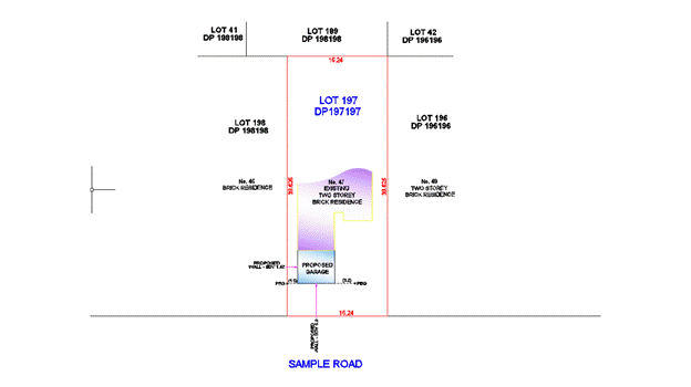
What is boundary survey drafting? A boundary survey is a crucial type of land survey that determines the precise location of property lines and the monuments that mark the property corners of a parcel of land as described in a deed.
A boundary survey is conducted by licensed surveyors to establish property boundaries, resolve boundary disputes, and ensure compliance with local regulations. It is a comprehensive process that combines research, fieldwork, and analysis of existing documents to create a detailed survey plat.
During a boundary survey, experienced surveyors carefully measure and map the property, taking into account the historical records, legal descriptions, and any physical evidence on-site. They identify and verify property corners, locate boundary lines, and document relevant details such as easements, encroachments and improvements.
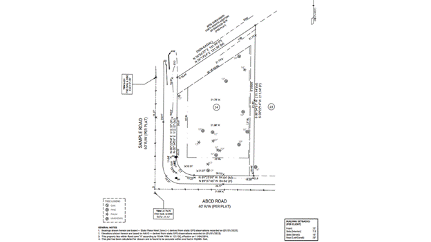
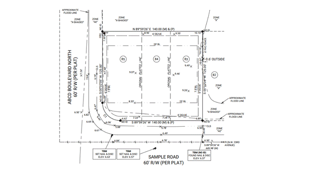
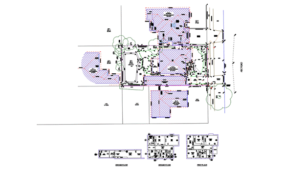
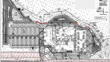
What’s included in a boundary survey Drawing?
A standard boundary survey drawing typically includes:
- Address and legal description. The legal description should include the lot #, the name and section or unit number of the development as listed on the plat, the plat book number and page numbers.
- Scale bar and north arrow: the scale should be 1”=20’ or 1”=30’. The drawing should not be twisted or rotated, so the north arrow should be pointing straight up to the top of the page.
- Flood Information: For each lot, please visit https://msc.fema.gov/portal/home , enter the lot address and city/state, and click search. After that update FIRM# effective date, flood zone, BFE.
- Exact property lines (both measured and platted)
- Bearings and distances based on state coordinate systems. Typically, two bearings/distances will be shown for each property line. The measured bearing/distance will be the closest to the property line and will be indicated by (M) at the end. (This bearing/distance will, most likely, not match the Plat). The platted bearing/distance will be the furthest away from the property line and will be indicated by (P) at the end.
- Street name: Most of these plats were created decades ago, and it is not uncommon for street names to have changed since inception. If you are unsure of the street name, the county GIS website may be helpful. The street name shown on the county GIS website is usually correct
- Centerline difinition: If the centerline is straight, its bearing should match the measured bearing of the front property line, and (M) should be added to the end of the bearing/distance label. If the centerline is curved, the bearing may not match, but (M) should still be included at the end of the curve label in the curve chart (e.g., C1(M)).
- Benchmark and elevations: The field crew will locate and/or set control points in the R/W, typically either along the centerline of the street or along the edge of pavement or back of curb. In addition to the elevations shown on the lot, there should also be elevations shown for the swale in front of the lot (if present), the edge of pavement or back of curb line, and the centerline of the street.
- Property corners: The field crew will search for existing monumentation at each property corner; however, monumentation will not always be found. If a pin is found a property corner, add a “found rebar” symbol from the legend, and then add a label for the LB# or LS# of the firm or surveyor that set it (if the LB# or LS# is not included in the field shot label, add a NO ID label instead). If no pin is found at a property corner, simply add a “rebar to be set” symbol from the legend (no label needed).
- Drainage and utility structures: All drainage and utility structures located in the field should be shown and labeled.
- Fence: all fences located in the field need to be shown and labeled include material and height.
- Trees: all trees located in the field with a caliper size ≥ 12” must be shown.
Step – by- step to complete a boundary survey
The following workflow outlines the typical steps taken to complete a boundary survey for a builder service package, from initial data review to final QA and PDF submission.
Step 1: Review all client provided data using the standard checklist
Review the checklist carefully and verify that all required documents and information have been provided, such as field notes, GIS aerial, recorded plat, subdivison CAD drawing, survey point data, …
If anything is missing, we will request the client to provide the missing items immediately.
Doing this early helps keep the project on schedule and ensures the final deliveries meet the client’s expectations for accuracy and completeness.

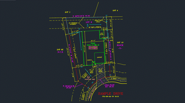
Step 2: Open the client’s subdivision CAD file in Civil 3D and import the survey point data
Use Autodesk Civil 3D to open the subdivision drawing provided by the client. Import the survey point file into the drawing. Set up the correct coordinate system in Civil 3D based on the zone indicated on the Plat (e.g., State Plane or UTM zone).
Then, verify that all imported points are displaying in the correct location to ensure the data aligns with the design base.

Step 3: Set up the appropriate viewport and scale for the subject property
Define a layout viewport that clearly displays the subject property and adjacent lots. (Common working scales are 1″ = 20′ or 1″ = 30′). It’s typical to offset the boundary of the subject property by 20 feet to include information from adjacent lots.
Based on the selected scale, adjust the text height, dimension styles, and labels to ensure clarity and consistency in the drawing.
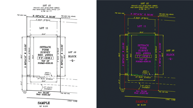
Step 4: Add setback lines and easement lines based on the Plat
Use the recorded Plat to draw building setback lines and easement lines, as these are usually not included in the original subdivision CAD file, which typically only contains the boundary lines.
Once these lines are added, make sure to label them clearly with the correct distances and notations, following the client’s drafting standards.
Step 5: Use point descriptions and field notes to accurately represent survey data in the CAD drawing
Use the point descriptions and field notes provided by the survey crew to accurately show all field-collected information. This may include:
- Benchmark locations
- Swales and drainage features
- Flood zone data
- Corner monumentation details (e.g., “rebar to be set”, “set ½” rebar”, “found Mag nail”, “found rebar”, etc.)

Step 6: Preview the drawing, export to PDF, and perform a final quality check before submission
Review the full drawing layout and preview all sheets.
Export the drawing to PDF format and go through the final QA checklist to catch any missing labels, incorrect linework, or formatting issues.
Make any necessary adjustments, then prepare the final file package for delivery to the client.
Aidedo’s pricing policy for boundary survey drafting services
At Aidedo, not only for boundary survey drafting services, but all other technical services are designed with two transparent pricing models, allowing clients to easily choose according to their specific needs:
1. Billing based on actual working hours
With this model, you will only pay for the exact amount of work that has been completed. In parallel, Aidedo provides a dedicated management platform for clients, where you can track the entire progress, execution time, and detailed reports for each project. This is a flexible solution, especially useful for projects with changing scopes or those expanding during implementation.
2. Fixed-price quotation for each work item
In cases where you need clear budget planning from the outset for approval processes or cost control, the fixed-price quotation model will be the suitable choice. Aidedo will collect your requirements, conduct a thorough analysis, and then provide a quotation and detailed implementation roadmap so you can easily track and feel secure throughout the execution process.
Regardless of the applied method, Aidedo always guarantees: if we don’t complete the work on schedule or fail to meet the committed criteria, you will not have to pay. Notably, we also support the execution of the first project for free, so you can experience the quality of our services before deciding on a long-term partnership.
If you want to know which pricing model is suitable for your project? Please send detailed project information to contact@aidedo.com or fill out the form below. Our team will respond within 1–2 hours, or within 12 hours at the latest, with a clear quotation and a commitment of no hidden costs during implementation.
Client feedback
Other services Aidedo provides
In addition to drafting boundary survey drawings, Aidedo also provides many other land survey drafting services to meet all of our clients’ surveying needs, such as:
TOPOGRAPHIC SURVEY
ALTA SURVEY
TREE SURVEY
BOUNDARY SURVEY
SETBACK SURVEY

FINAL SURVEY
CONTOURS PLAN
PLOT PLAN
DETAIL/INTERNAL SURVEY
SET OUT/PEG OUT SURVEY
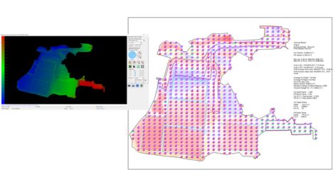
3D SURVEY MODELING
POINT CLOUD TO FLOOR PLAN, ELEVATIONS
AS-BUILT SURFACE 3D MODEL
GRADING TAKEOFF USING CARLSON SOFTWARE
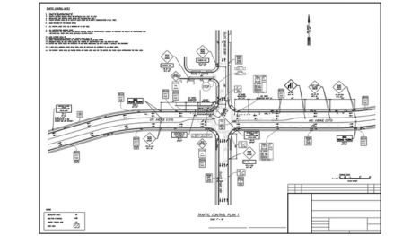
TRAFFIC CONTROL PLAN
Our collaboration process at Aidedo
At Aidedo, we believe that a clear, convenient, and flexible process is the foundation for effective and long-term partnership. Our collaboration process is streamlined into just 3 core steps:
Step 1: Submit Your Request
First, you can send your request to us via email at contact@aidedo.com or by filling out the online form directly below this article. Providing detailed information from the outset will help our team better understand your actual needs and direction, and from there, quickly propose a suitable solution.
Step 2: In-Depth Online Discussion
After receiving your information, we will proactively schedule an online discussion via Google Meet, Zoom, Microsoft Teams, or any internal platform you are currently using. The goal of this discussion is to clarify the scope of work, costs, collaboration methods, and implementation process. Simultaneously, we will showcase sample projects relevant to your actual needs, answer any questions, and provide a more comprehensive view of Aidedo’s capabilities. This is also an opportunity for both parties to meet and converse before officially commencing cooperation, demonstrating professionalism and good faith in building a sustainable partnership.
Step 3: Utilize the Free Trial
Once everything has been agreed upon, Aidedo will begin with an initial project in the form of a free trial. In this phase, we carry out the work with the same process and quality as an official project, giving you a basis for actual evaluation before making a long-term cooperation decision. In some cases, when clients have urgent deadlines, we can immediately begin with the actual project after the consultation. Regardless of the form, you always have the right not to pay if you are not satisfied with the quality of the output we deliver.
Overall, if you are looking for a boundary survey drafting service solution that is accurate, flexible, and saves time and operational costs, then Aidedo is the right partner for you to start with and accompany long-term. With strong professional capabilities, a professional implementation process, transparent support policies, and a clear commitment to quality, Aidedo not only provides standard-compliant drawings but also helps you confidently expand your capacity, control project progress, and enhance technical efficiency in every project.
Please contact Aidedo via email at contact@aidedo.com or fill out the registration form right below to have our team of engineers consult with you and experience our boundary survey drafting service for your first project for free. We are ready to support you from the very first steps and are committed to delivering long-term value in every collaboration.

GET STARTED WITH A FREE TRIAL
Please fill out the form and we'll be in touch within 12 hours!
Related posts
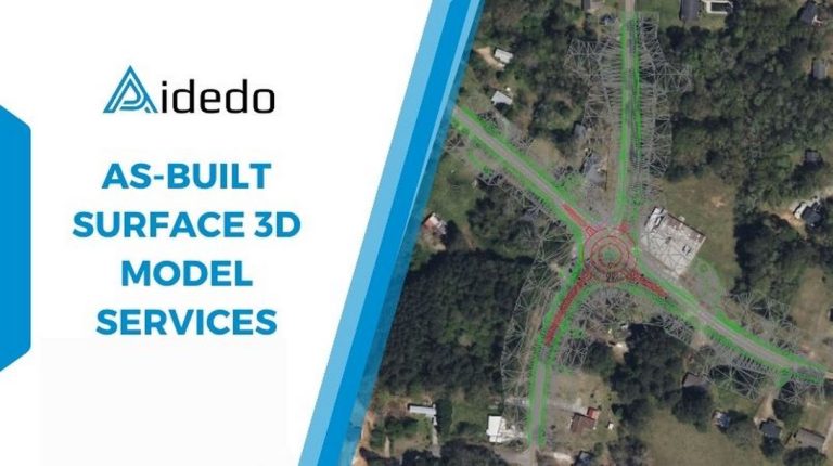
AS-BUILT SURFACE 3D MODEL SERVICES
As-Built 3D surface model services have become a practical solution for the land survey industry,...
Discover Premium CAD Services with Aidedo
Efficiency and accuracy are critical in design and engineering, especially for businesses in construction, civil...

Builder Survey Drafting Outsourcing Services
Are you a land surveyor company looking to enhance your service offerings for builders and...
Land Survey Drafting Outsourcing Services – 50% Cost Savings
Are you looking for a land survey drafting service for your company’s projects? Are you...

Expert Civil Engineering Outsourcing Services in Vietnam
Are you currently using civil engineering outsourcing services for your company’s projects? Do you want...
OUTSOURCING 3D SURFACE MODELING SERVICES
Outsourcing 3D surface modeling services are increasingly necessary in civil engineering and land surveying projects,...