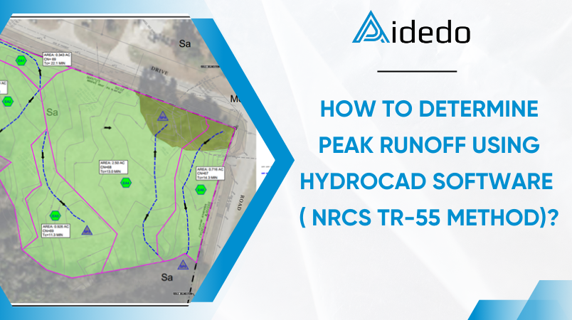
HOW TO DETERMINE PEAK RUNOFF USING HYDROCAD?
(SCS TR-55 METHOD)
PURPOSE OF PEAK RUNOFF CALCULATION:
- Protecting downstream areas from flooding
- As urban development increases, impervious surfaces expand, leading to higher stormwater runoff volumes. Calculating peak discharge helps regulate flow to prevent flooding in downstream areas.
- Designing and optimizing drainage systems
- Determining peak discharge is essential for designing stormwater drainage systems, detention ponds, and flood channels to ensure efficient water conveyance and mitigate flood risks.
- Controlling and managing water quality
- Peak discharge directly affects the volume of runoff carrying pollutants. Accurate calculations help design stormwater treatment systems, such as retention basins or sedimentation tanks, to reduce pollution.
- Complying with planning standards and environmental regulations
- Stormwater management regulations require peak discharge calculations to ensure that a development project’s drainage system does not negatively impact surrounding areas.
- Forecasting and mitigating natural disaster impacts
- By modeling peak discharge for different storm event return periods (e.g., 2-year, 5-year, 10-year, 25-year, 50-year, 100-year events), planners can anticipate the effects of heavy rainfall and implement mitigation measures.
Several standard methods are available for calculating peak stormwater runoff, including the Rational Method, Modified Rational Method, and the SCS TR-55 (now NRCS TR-55) method. This document focuses on applying the NRCS TR-55 methodology, originally developed by the USDA in 1986. This approach is best suited for small, homogeneous drainage areas typically less than 2,000 acres that can be characterized by a single Curve Number (CN).
The peak discharge is computed using the following equation:
Qp = qu A Q Fp (1.1.1)
Where:
Qp = peak discharge ( cfs)
qu = unit peak discharge ( cfs/mi2/in)
A = drainage area (mi2)
Q = runoff (in)
Fp = pond and swamp adjustment factor
Table 1: Adjustment Factor (Fp) for pond and Swamp Areas that are spread throughout the watershed.
| Percentage of Pond and Swamp areas | Fp |
| 0 | 1.00 |
| 0.2 | 0.97 |
| 1.0 | 0.87 |
| 3.0 | 0.75 |
| 5.0 | 0.72 |
Source: USDA, TR-55.
HydroCAD allows users to input these variables with precision, select appropriate unit hydrograph models, and evaluate the resulting hydrographs and peak flows under various storm scenarios. The software also supports model adjustments and automatically recalculates outputs to reflect any design changes.
The following sections present a step-by-step procedure used to calculate stormwater runoff using HydroCAD.
COMPUTATION PROCEEDS FOR THE PEAK DISCHARGE
Step 1: Getting precipitation frequency and type of rainfall distribution.
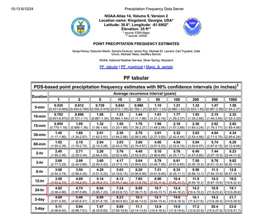
Based on the project location ( Latitude; Longitude) and The 24-hour rainfall depth is determined from the precipitation data in the NOAA Atlas 14 publication, or online using the Precipitation Frequency Data Server database (http://hdsc.nws.noaa.gov/hdsc/pfds/)
This is the result of this looking for:
| Years | 1 | 2 | 5 | 10 | 25 | 50 | 100 |
| Intensity (inch) | 4.02 | 4.74 | 6.04 | 7.24 | 9.09 | 10.7 | 12.4 |
| Type II rainfall distribution. | |||||||
Read more: GUIDELINE FOR COMPLETING THE STORMTECH CHAMBER SYSTEM REPORT USING HYDROCAD
Step 2: Determine Curve Number (CN).
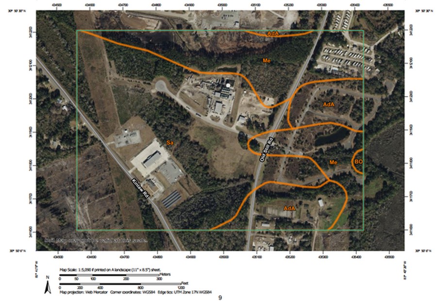
Based on Geological report or Custom soil resource Report Soil map to find hydrological soil groups (A, B, C or D). Then the CNs are determined relationships based on the type of land cover and soil group.
Step 3: Determine the time of concentration flow on site.
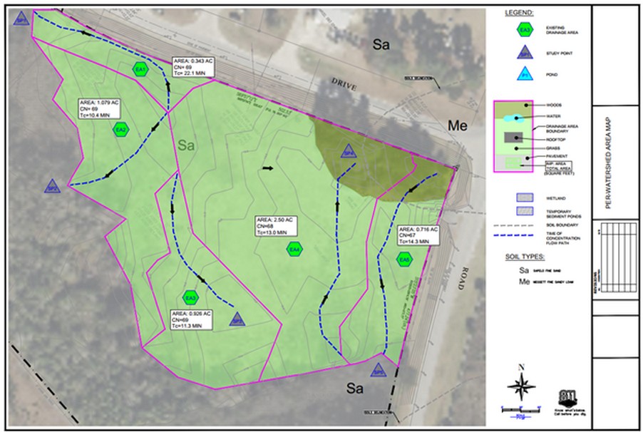
Travel time (Tt) is time it takes water to travel from one location to another within a watershed, though the various components of the drainage system. Time of concentration (Tc) is computed by summing all the travel times for consecutive components of the drainage conveyance system from the hydraulically distant point of the watershed to the point of interest within the watershed.
Water moves through a watershed as sheet flow, shallow concentrated flow, open channel flow.
Read more: HOW WE ESTIMATE WORKING HOURS BEFORE STARTING A PROJECT AT AIDEDO?
Step 4: Entering design data into HydroCAD.
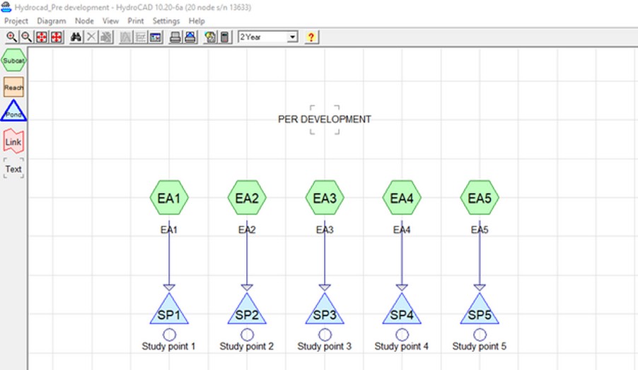
In HydroCAD, initiating hydrologic analysis requires the input of several key parameters, including the selected runoff method, rainfall, timespan and unit hydrograph. Depending on project-specific requirements and the watershed area, the calculation method is selected suitable as the Rational Method or the SCS TR-55. Several types of unit hydrograph models are available to represent the relationship between rainfall intensity and time, including the Standard SCS, PF=300, and PF=484. The selected hydrograph model should align with the local municipality’s design standards.

Read more: Civil Engineering Outsourcing Services
Step 5: Build Hydrologic and Hydraulic modeling by HydroCAD.
At this stage of the design, a comprehensive and accurate characterization of the contributing watershed is required, including identification of the hydrologic and hydraulic at analysis points, as well as the design outlet control structures. These elements may consist of weirs, orifices, culverts,detention pond, tailwater conditions.
Step 6: Results analysis and Data export.
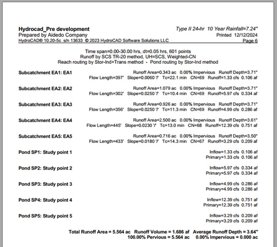
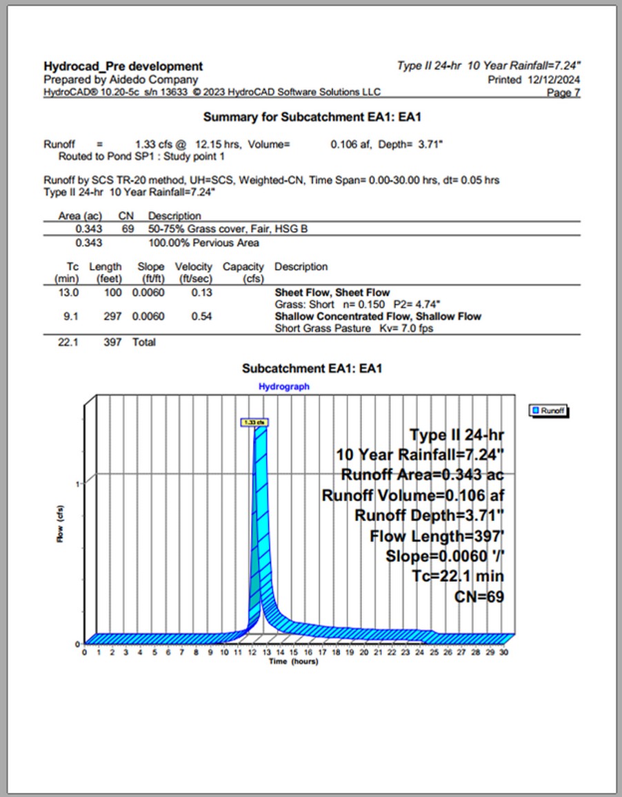
After verifying the model results, the HydroCAD report format can be used to prepare official documentation for submittal to permitting authorities as part of the design approval process. In addition, the calculated results such as peak flows, runoff volumes, and stage-discharge data can be utilized to update other related design components, including grading models or pipe network modeling.
Read more: WHY DO WE NEED TO REPORT DAILY PROJECT PROGRESS & QUALITY?
Accurately determining peak runoff is not only essential for infrastructure design but also critical for ensuring safety, sustainability, and regulatory compliance. Leveraging HydroCAD software with the NRCS TR-55 method empowers engineers to model stormwater behavior effectively, optimize drainage systems, and mitigate flood risks across a wide range of project types.
If you’re looking for support with hydrology simulations, stormwater drainage design, cut & fill calculations, or Civil 3D modeling, our experienced engineering team at Aidedo is here to help.
For more information, don’t hesitate to contact us at contact@aidedo.com
Or book a free 1:1 consultation with one of our specialists today to explore how we can support your project effectively.
We guarantee a response within 12 hours!

